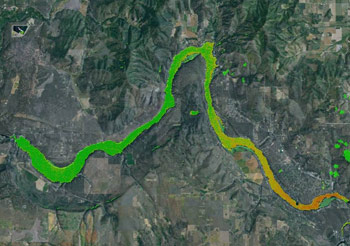
AquaTechnex provides Bluewater Satellite services to our clients throughout the Nation. This technology processes LANDSAT image data to map a number of critical water quality parameters such as phosphorus, chlorophyll a and cyanobacteria/toxic algae. This system samples the water surface at five locations per acre and provides a complete picture of conditions across large water bodies that grab sampling will not. It is a very cost effective technology to monitor and understand the levels of these key constituents. It can also be used to perform historical analysis looking at conditions up to 25 years ago to track change over time or assist in development of TMDL models.